earthquake
Bravo Pakistan TV anchor continues live reporting while earthquake is going on…
Pashto TV channel Mahshriq TV during the earthquake. Bravo anchor continued his live program in the ongoing earthquake. #earthquake #Peshawar pic.twitter.com/WC84PAdfZ6 — InamAzal Afridi (@Azalafridi10) March 21, 2023
Last time this cloud formation was seen… it was turkey before the earthquake – now seen in Argentina
Pray for Argentina…. pic.twitter.com/lwoimItKVE — PaulsCorner-VerseQuest (@TNTJohn1717) February 13, 2023 https://twitter.com/_/status/1625090175066857475 h/t JADR
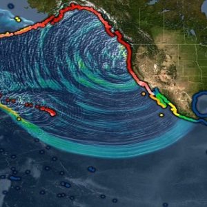
Middle East Earthquake: 22,000 Confirmed Dead So Far
by Chris Black The body counting hasn’t really even begun. BREAKING: Turkey-Syria earthquake death toll passes 22,000https://t.co/KtyJT8oOOZ — Pubity (@pubity) February 10, 2023 Surface fracture in Turkey following the two deadly earthquakes. Gives you an idea pic.twitter.com/Xcrll8IFFX — Ragıp Soylu …
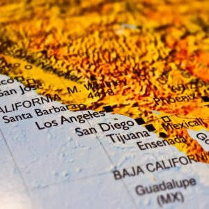
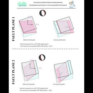
HAARP caused Turkey’s earthquake? (Turkish reporters claim earthquake caused by “artificial means”)
https://twitter.com/_/status/1623372167994871835 https://twitter.com/_/status/1622951077480996864 HAARP firing up before the quake hits. Let's be realistic and not ignore that Haiti experienced the same thing. pic.twitter.com/2FbXynGc52 — Gouryella🇨🇦 (@gouryella99) February 7, 2023 This is what HAARP can do 👇Yes even cause Earthquakes pic.twitter.com/U6TZ1BpKxB — …
Little girl offers to be rescuer’s servant if he can free her and baby brother from earthquake rubble
Young Syrian girl shields her brother beneath the rubble of their destroyed home, trapped under heavy concrete for 17 hours. The destruction of human life is unfathomable. “I beg you to get me out.I’ll do whatever you want. I’ll even …
Dutch researcher warned for this Earthquake in Turkey 3 days ago…
Frank Hoogerbeets is a researcher at the Solar System Geometry Survey (SSGEOS), a research institute for monitoring the geometry between celestial bodies that can lead to increased seismic activity and other physical effects. Last week, SSGEOS posted another video in which …
A Financial Earthquake is Coming

““The combination of recession and rising real interest rates is very dangerous,” says Harvard professor Ken Rogoff, a former chief economist at the International Monetary Fund.” https://finance.yahoo.com/news/central-banks-risk-setting-off-153227013.html Rafi Farber “The End Game For the Monetary System Could Begin in Japan” …
Just One Day After An Ominous Warning, The California Coast Was Hit By An Enormous Earthquake
by Michael This wasn’t “the Big One”, but hopefully it will serve as a wake up call for millions of California residents. The magnitude 6.4 earthquake that just struck northern California killed two people and caused quite a bit of …
Italy braces for political earthquake on eve of elections expected to hand the country the most right-wing government since World War Two
by Boo_Randy For decades, Italians have voted for globalist stooges like former ECB head Draghi who ran the country like a neoliberal corporate looting plantation for the benefit of the WEF, etc. Now disillusioned voters are prepared to give the …

Earthquake incoming!!! “Once In A Lifetime” Sighting: Giant Deep-Sea Squid Carcass Washes Up On New Zealand Beach
“Once In A Lifetime” Sighting: Giant Deep-Sea Squid Carcass Washes Up On New Zealand Beach https://t.co/x8tsG8Br9f — TheSpuzz (@Thespuzz) September 13, 2022 h/t A Deplorable Neanderthal
Experts warn California of a disaster ‘larger than any in world history.’ It’s not an earthquake.
Megadrought may be the main weather concern across the West right now amid the constant threat of wildfires and earthquakes. But a new study warns another crisis is looming in California: “Megafloods.” Climate change is increasing the risk of floods …
Fed Unleashes The Next Big Financial Earthquake Inbox
via CNBC: The Federal Reserve on Wednesday enacted its second consecutive 0.75 percentage point interest rate increase, taking its benchmark rate to a range of 2.25%-2.5%. Chair Jerome Powell said there will be a point where the Fed starts to …

AND IT SHOULD BE: If the Wuhan lab-leak hypothesis is true, expect a political earthquake.
via Yahoo: I am no expert on epidemics. Like everyone else I know, I spent the pandemic doing as I was told. A few months ago I even tried to talk a Fox News viewer out of believing in the …
Fed’s Financial Earthquake Warning: Are There Cracks in Your Assets?…by Lynette Zang

ITM Trading, Released on 5/20/21 Lynette Zang has held the position of Chief Market Analyst at ITM Trading since 2002. Ms. Zang has been in the markets on some level since 1964. Her mission is to convert financial noise into understandable language. …
CBS Discovers Political EARTHQUAKE Shaking California, Worries GOP Is ‘Hijacking’ Recall
A political earthquake is shaking California as a massive recall effort against liberal Governor Gavin Newsom has surged past the needed 1.5 million signatures to qualify for a fall ballot. The networks have mostly stayed silent on the unpopular Democrat’s …
Foreshock For Something Bigger? A Magnitude 4.6 Earthquake Just Struck A Fault Line Off The Coast Of Northern California
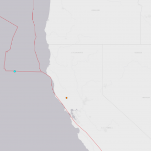
by Michael Snyder An unusually large earthquake just hit the west coast. According to the USGS, a magnitude 4.6 earthquake that was centered directly on a fault line happened approximately 221 kilometers west of Ferndale, California on Friday. Fortunately it was far …
The Largest Earthquake In 45 Years Hits Tennessee – Is The “Deep Underground Scar” In The Center Of The United States Awakening?
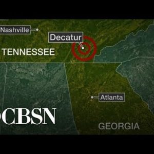
by Michael Snyder Large earthquakes aren’t supposed to happen in Tennessee. On Wednesday, the largest earthquake in 45 years hit eastern Tennessee, and it made headlines all over the nation. The magnitude 4.4 quake was so powerful that it was …
Mark Taylor – God Is Going to Gut MSM News Media, Red Tsunami After Earthquake of Mass Arrests

Mark Taylor, author of the popular book “The Trump Prophecies,” says, ““The news media is going to be gutted. God is done with the news media. When Donald Trump says the fake news is the enemy of the people, he …
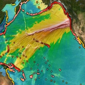
You Have Been Warned: Experts Tell Us That A Cascadia Subduction Zone Earthquake And Tsunami Will Destroy Everything West Of Interstate 5

by Michael Snyder One day it will happen. With little or no warning, the Cascadia Subduction Zone will produce a catastrophic earthquake and accompanying tsunami that will essentially destroy everything west of Interstate 5 in the Pacific Northwest. It will …
‘Political earthquake’ in Bavaria as Merkel’s sister party CSU likely to lose its majority

https://www.youtube.com/watch?v=dei19Y__VXs Germany’s political landscape is crumbling as Merkel’s sister party, the CSU, has only received 35.5% of the votes in Bavaria, an exit poll shows. Meanwhile, the anti-establishment AfD has entered parliament for the first time.
Michio Kaku – California Overdue for a Major Earthquake ( Prepare to Survive and Recover From the Next Damaging Earthquake )
by Amy S. California is the land of beaches, mountains, and all the legal marijuana you can stomach. It’s also, inconveniently, a dangerous minefield riddled with nasty fault lines that rupture without much warning, generating massive earthquakes that can …
FEMA Warning! Get off the Coast! California Under Earthquake Threatens! This Event Will Hit The Entire West Coast And Change The History Of America
by Amy S. Latest research suggests that the San Andreas and San Jacinto faults might have ruptured together in the past, and may again trigger more powerful destruction Measuring the level of threat posed by severe earthquakes that could bring havoc …
Peru rocked by 7.1 magnitude EARTHQUAKE, Rings of Fire Rocks
https://www.youtube.com/watch?v=NsnEmSHCoEc The quake struck 155 miles north-west of Puerto Maldonado in south-eastern Peru. http://marygreeley.com/?p=74474
Fiji Earthquake 8.2 – More to Come?

by Martin Armstrong COMMENT: Ok, this time you were wrong. A major earthquake hit Fiji on the 19th, not the 20th and CNN reported it 3 hours ago which followed your post 8 hours ago. Your slipping! Cheers Keep up the great work …
Texas earthquake history

https://www.youtube.com/watch?v=cpiPgYLBlk0 Almost all of the earthquakes in Texas have been caused by one of two sources. The major source is relief of tectonic stress along fault lines. These are most common in the Rio Grande rift belt, the Panhandle, the …
Second-largest earthquake in modern South Korean history tied to geothermal plant fracking
https://www.youtube.com/watch?v=iDsjm3oxKYI The pair of studies, published online on 26 April in Science1,2, heighten scrutiny of the potential role of the geothermal plant in the quake, which was South Korea’s second-strongest since observations began in 1978 and the most destructive ever …
WallStreet De-FANGed as Dot.Com Bubble 2.0 POPS! Before An Earthquake, There Are Periods Of Calm, Followed By Minor Tremors Called Foreshocks.
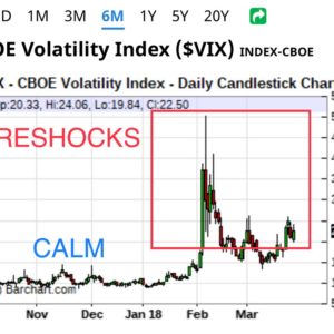
https://twitter.com/PlanetPonzi/status/978985563717013504 COMPLEX SYSTEMS EXHIBIT SIMILAR DYNAMICS Before an earthquake, there are periods of calm, followed by minor tremors called foreshocks. Then the violence of the quake, and aftershocks. The #Financial / #StockMarket is no different. What we are seeing are …